
Update – A downloadable copy of the Guiseley Gap Walk is here.
In 2016 we reported that one of Aireborough’s unique landscape features, the Guiseley Gap, had been lost from official documents and local understanding – yet, it was the first intriguing feature the President of the Royal Geographical Society, Nicholas Crane, noted when he visited the area. The Forum promised to improve knowledge of the Guiseley Gap, and to that end we have written and published a new walk leaflet, Guiseley Gap Circular Walk, in conjunction with the North West Leeds Country Park using funds donated by Guiseley and District Lions.
In the Aireborough Neighbourhood Forum’s 2017 Landscape Study, we concluded that the most important part of the Aireborough landscape – known to geologists as The Guiseley Gap – had been overlooked in both Leeds and Bradford Council’s strategic planning. This was a detrimental oversight owing to the crucial part the Gap plays in the water tables, drainage, and ecology networks – as well as its part in the cultural and historic landscape.
The Gap has been a means of easier travel in northern Britain from prehistoric times, with tracks crossing north south and east west. The Roman, Viking, Medieval and Civil War periods have all seen it play a part in defence. The local water and wood resources were the reason for the development of the area, first for cattle farming and subsequently textile mills. In the late 19th and early 20th century there are regular reports of queues of people at Leeds Tram Terminus on Bank Holidays waiting to catch a tram to White Cross and explore the landscape.
The Guiseley Gap is also little appreciated by current local people, its profile and features having to a great extent been hidden by increasing development since the early 20th century. Yet, when you know the landscape characteristics or look at them from afar the glacial and water features around us because more obvious. The Gap is perhaps at its most dramatic coming along Yorkgate from The Royalty towards Chevin End.

The Guiseley Gap is a millstone grit ‘hanging valley’, between Airedale and Wharfedale. At both the northern and southern edge there are ghylls that drain the many becks flowing from surrounding hills such as Reva and The Chevin down to the lower level river valleys; ie to the north Ellar Ghyll takes Mire Beck to the Wharfe, and to the south the Ghylls take Guiseley Beck and Gill Beck down to Esholt and the Aire. The lower levels of the gap are wet and contain mires, that for centuries have been used for cattle ings and leys, whilst the valley sides contain a range of woodland and grassland depending on height and ‘soil type’ – as demonstrated here in Parkinson’s Park.
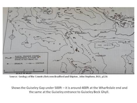
The Gap was formed in the Devensian glacial period which lasted from 70,000-10,000 BC. A branch of the Wharfedale glacier exploited an old dry river valley to spill across the millstone grit landscape and watershed of what is now Rombolds Moor to join up with an Airedale glacier. It pushed through the V shaped river valley to eventually make a wide U shaped glacial valley which at its lowest point was still several hundred feet above the Wharf and Aire. It is also suggested that as climate warmed the connection to the Airedale glacier broke down and that the Guiseley Gap was occupied by a lobe of Wharfedale ice at the northern end with a lake being formed against Airedale ice at the southern end.
As the ice slowly retreated it left a landscape covered in glacial deposits, these range from Lanshaw Delves a ridge of morraine on the western side of the Gap near Reva, to lumps of morraine on the ‘hanging valley’ floor which form the landscape around West Carlton, and where Fieldhead School, Guiseley is. Also the glacial till which makes the whole lower area slippery when it is wet. The Chevin Geological Interpretation Board has some very useful diagrams, whilst the Geology Board in Parkinson’s Park Guiseley also has some explanations. After formation the Guisley Gap was subsequently exploited and shaped by both nature eg woodland and grassland and human endeavour.
Now, you can explore the Guiseley Gap its features and history with our new walk leaflet. Researched by the Forum and designed by the Leeds North West Leeds Country Park team, it loops off the Green Gateways trail ( a 41 mile circular trail which explores green corridors in the North West Leeds Country Park) on the Chevin in an 8.8 mile circular walk across the gap. However, it can be picked up at numerous places en route, including Thrope Lane, High Royds, Parkinson’s Park and Wills Gill.

The Guiseley Gap Circular Walk leaflet is available in all local libraries (Guiseley, Menston, Ilkley, Otley, Rawdon, Yeadon, Burley, Horsforth, Otley Courthouse. Aireborough Leisure Centre). Some of the libraries also have a stock of the Green Gateways leaflet, but those are more rare. If you are unable to get a copy of the leaflet let us know on aireboroughnp@gmail.com.
We are grateful for support on development of the leaflet from
West Yorkshire Geology Trust
ANDF – Lynda Kitching, Jennifer Kirkby Steve Howarth, and Cllr Ryk Downes
Photography – Darren Sanderson Photography
Design and walk test – Doug Louis, North West Leeds Country Park
Funding for the printing – Guiseley and District Lions
Printing was done by Gecko, Yeadon

You must be logged in to post a comment.