Government rules on the deletion of Green Belt state –
“The NPPF makes it clear that ……. only in exceptional circumstances may a local authority alter the green-belt boundary, after consulting local people and submitting a revised local plan for formal examination.”
“Green Belt boundaries should be amended only in exceptional circumstances when local authorities can demonstrate that they have fully examined all other reasonable options for meeting their identified housing requirements.”
In their current Site Allocation Plan Revision, currently out at public consultation, Leeds City Council say they have chosen a number of Green Belt sites in Leeds for deletion, because thy are (links to key paper given).
“the most preferable sites to release in Green Belt Review Terms – those having least affect on 5 purposes of Green Belt, site attributes (including local views), as well as sustainability assessments. In addition the assessment has considered sequential preference of the release of Green Belt sites, so that in most cases, those with the least impact on Green Belt Purpose have been released, with the remainder being designated as Broad Location pending review of the Plan”2.30 SAP Submission
We have been looking at some of the evidence for the LCC claim on the 4 Aireborough Green Belt sites, chosen for housing delivery before the year 2023. If you would like to comment to LCC on these sites, or write to local MPs details are here. You will need to do so before 5pm on 26th February 2018.
Ings Lane, Guiseley – 160 houses
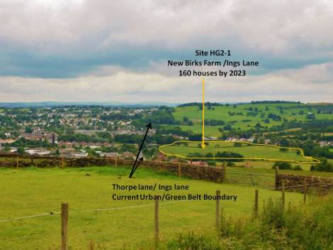
Ings Lane – 160 Proposed Houses on a Flood Plain
At the last Inspector led Planning Enquiry on this site around 1999, the Inspector concluded the following.
“It is necessary to consider the extent of the contribution this site makes to the purposes of Green Belt. I regard the settlements of Menston and Guiseley as being distinct, and consider that it is important to maintain this separation. Despite the existing sporadic development along and near Bradford Road there are sufficient glimpses of open land behind and around that development still to provide a sense of real separation. Even Moorland Crescent does not wholly remove it, but I consider that further development on the Ings site would be very likely to contribute to that effect, even if buffer areas and extensive landscaping were to be employed. I regard the continued openness of this land as fulfilling, above all, the function of separating the two existing communities of Menston and Guiseley, and the contribution the site makes to the Green Belt is so great as to override the need to identify land for immediate or possible longer term residential development.”
In the Leeds City Council 2013 Green Belt Assessment for this site they conclude that “the site would not merge settlements, and would round of Guiseley”
However,
If we look at the Bradford Growth Strategy for 2013, where they looked at this Green Belt boundary from the Menston perspective the conclusion is:
1. The Green Belt surrounding Menston has a significant role in the restriction of sprawl of built-up areas to the to the south along the A65 and railway corridor
2. The Green Belt around Menston contributes towards helping prevent the merging of Menston and the neighbouring settlements such as Guiseley.
3.The Green Belt around Menston performs a significant role in safeguarding the countryside from settlement encroachment.
So what do you think?
Wills Gill, Guiseley – 133 Houses
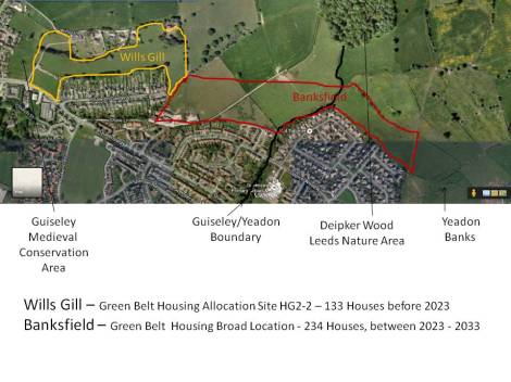
Wills Gill – Historic Green Belt Site for 133 Houses
Wills Gill, outlined in yellow, was initially rejected for housing development in 2013 by Leeds City Council as they said it “performed an important role in safeguarding the countryside from encroachment” – one of the purposes of Green Belt.
Historic England have been very unhappy with the proposed development of this Green Belt site, as it is part of the medieval field system that creates local character in Guiseley. Another purpose of Green Belt is to help historic character.
In the Aireborough Landscape Character report it said ” this study has identified the area as a place where the built-up area is in ‘tension’ with the neighbouring open landscape character. The Wills Gill landscape’s contact with the countryside is fundamental to the character of Guiseley. This point of connection is already squeezed to its limit and could easily be lost.”
Lastly, this site was/is planned as part of a larger urban extension with the CoppiceWood/Banksfield area, so that access is available from both Queensway and Banksfield. But now Banksfield has been put into a category of Green Belt Broad Locations that could be used after 2023. So, Wills Gill on its own will have highway access issues, although after being built, it will open up access to the building of the Banksfield site.
In spite of all of this, the Wills Gill site is now one of four Green Belt sites in Aireborough earmarked for housing to be built before 2023. Leeds City Council consider it to be a site that has ‘least impact’ on Green Belt purpose, and to be more sustainable than other sites in Leeds. What do you think?
Hollins Hill, Guiseley – 80 Houses
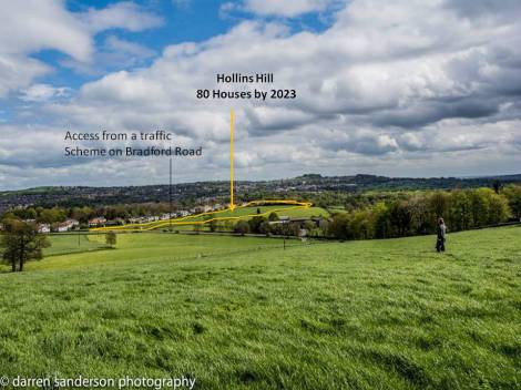
Hollins Hill – Working Farm on Green Belt for 80 Houses
Hollins Hill is a working farm and part of Aireborough’s Green Belt stopping sprawl and encouraging regeneration of brownfield sites in Leeds and Bradford.
It is also listed as part of the West Yorkshire Strategic Green Infrastucture. The Aireborough Landscape Report concluded that
“the study has identified the area as a place where the built-up area is in ‘tension’ with the neighbouring open landscape character. Development in this area is already insensitive on the legibility of the Hawkstone ridge and is destroying the links in strategic green infrastructure. Land on the Bradford side of the border is recognized as a place to conserve and restore – not so the Leeds side. This is a point of cross-border conflict.“
However, Leeds City Council concluded in their Green Belt Assessment of 2013 that “Site does not perform an important role in safeguarding the countryside from encroachment.”
LCC therefore plan to delete the site from Green Belt and build 80 houses; access will be from the A6038 with a road scheme to allow for turning into the new estate. What do you think?
Victoria Avenue, Yeadon – 102 Houses

Victoria Avenue – Ideal Location For Plane Spotters.
Victoria Avenue Yeadon is at the top of Tarnfield Park, it is right next to the runway.
The site is owned by Leeds Bradford Airport, and was put in the site allocation plan by the last owners (not the current owners), who wanted to use the funds to build the Innovation Park on the 36.23 hectare Green Belt site on the other side of the airport.
The site of the Innovation Park is controversial as it is Green Belt land. Green Belt should only be used were there are exceptional circumstances, and all other possible options have been looked at. Paper from LCC here.
The Planning Inspector at the October SAP hearings wanted to know why Coney Park and the Avro building, both brownfield sites, had not been looked at as possibilities for the Innovation Park. Coney Park brought a barrister to argue the case.
The Innovation Park, will need an airport link road.
The potential housing site at Victoria Avenue, would be a much better extension to Tarnfield Park. It is moorland wetland, and could help in joining ecological habitat networks across Yeadon Moor. What do you think?
Postscript
There is one final quote that is worth making. When the last Urban District Plan for Leeds was made in 2006/7, Leeds City Development wrote a report on Guiseley and all the issues that were being caused then by new development. They concluded that
” Guiseley is protected by a tight Green Belt boundary and it is important that it remains so to prevent Guiseley from becoming an extension of suburban Leeds or merging with Bradford. To ensure that the Green Belt, and land which has not been developed (greenfield land), is protected there is a need to make best use of previously developed land. “ (LCC City Development Report 2007)

You must be logged in to post a comment.