During 2016 the Aireborough Neighbourhood Development Forum has undertaken three major projects, on
- Landscape Value,
- Ecology and Biodiversity,
- Housing Need,
The aim of these projects is to provide important written evidence for the Neighbourhood Plan, the Leeds Site Allocation Plan, and to update relevant databases such as those of West Yorkshire Ecology , West Yorkshire Archaeology, and Historic England.
This work has been funded with the help of grants from Locality and donations from local people to purchase expert consultancy, support from local Councillors and Local Giving to fund materials and workshops, and volunteer time and expertise to collect the data. In Neighbourhood Planning, a strong evidence base is crucial, and the more the work can show it has engaged a wide variety of local people to help, the more credibility it has as the ‘voice of the local community’.
Landscape Value
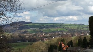
The Guiseley Gap
The Landscape Value report was guided by a very experienced professional Landscape Architect, Tom Lonsdale, who used to be Head of the subject for Manchester City Council, and works closely with Design Council CABE. Landscape is about a sense of place, and the value that brings to wellbeing and resources. We start with geology, and geomorphology (how nature shapes the land) but from there we shape our landscape and it shapes us in return – for the better or worse
The output from this project has divided Aireborough’s landscape into 17 different ‘cells’ each with its own characteristics. It has also looked at where the landscape is under greatest threat, and how it can be conserved and restored. This information will all form the proposed planning policies in the Neighbourhood Plan – with your help.
One of the key facts we have established is the way the Leeds and Bradford boundary dissects Aireborough, means that neither local authority has recognized the key feature of our unique area – that we sit on a millstone grit ‘hanging valley or plateau, between Airedale and Wharfedale – The Guiseley Gap. At either sides of the valley we have ghylls that drain the becks full of water from hills such as Reva and The Chevin – eg to the north Ellar Ghyll takes Mire Beck to the Wharfe, and to the south the Ghyll that goes down to Esholt down Coach Road takes Guiseley Beck to the Aire.
The re-establishment of this important topology needs putting back into the planning and design of Aireborough and a report is currently being written by Tom Lonsdale and Jennifer Kirkby with lots of useful and interesting facts.
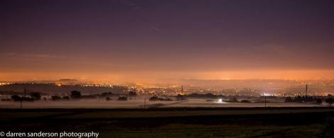
Aireborough from Carlton Lane
We are also thankful to local professional photographer Darren Sanderson, who has now spent more than a year, capturing our landscape to illustrate the reports, as well as provide a pictorial source for use in a variety of materials and as a library for the future.
Ecology and Diversity
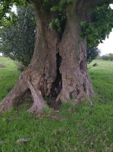
Old stubbed sycamore on Cow Wood Pasture.
This project has been led by professional ecologist, Richard Wilson, again with a team of volunteers; many very knowledgeable in ecology themselves. The aim has been to map out key local habitats and look at their biodiversity, with a view to improvement, and linkage. The ecology will link into the landscape cells.
From May to August the volunteers went out and each surveyed a particular area of Aireborough, noting plants, insects, birds and wildlife. A number of unknown or perhaps forgotten habitats revealed themselves – the edges of old hay meadows that were destroyed post WW II with modern farming methods – hay meadows are being increasingly restored across the country. The remnants of old managed woodland, and even possible wooded pasture – once a key habitat in this area, and under threat nationally.
Richard is currently analysing all the data that has been produced and will report early next year. Again the information will be used to put forward policies for improvement, conservation and restoration of Aireborough habitats in the Neighbourhood Plan.
Housing Need
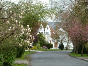
Tranmere Park – Garden Village
The work on housing need has drawn on 2011 census data, but has also surveyed local opinion and behaviour led by our Project Manager Frank La Corte. The data has been analysed by expert statistician Dr Pete Shepherd who has expertise in developing housing need analysis. We will be reporting at a later date on the output. We are hopeful that this information will feed into any new Strategic Housing Market Analysis that Leeds produce to justify a new housing target – the work has therefore been critical.
Many different people have lent their time, money and expertise to these projects – and they all deserve a very big Thank You, especially our Secretary Liz Kirkpatrick who has organized all the volunteers.
This work now joins the 2015 work done by AECOM on the conceptual green infrastructure.
You can find more about our progress in our 2016 AGM report, here.

You must be logged in to post a comment.