Infill or a merging of the settlements of Guiseley and Menston? You decide
Leeds City Council Executive Board saw a heated discussion on the proposed site allocations on Wednesday 15th July 2015. This ended in Cllr Andrew Carter (Leader, Conservatives), and Cllr Stewart Golton (Leader, Liberal Democrats) abstaining from the vote to approve the site allocation publication plan.
The discussion included the fact that brownfield development is coming forward all the time in Leeds, and that the Government has recently signalled their intention to make building on brownfield easier through a number of measures. This, in addition to the fact that the current site allocation plan has 330 more houses allocated than needed, should all impact to reduce the ‘housing and employment need’ that Leeds are claiming is their exceptional circumstance for taking land out of the green belt: but, there seems to be no recognition of this in the Council.
The site allocation publication plan was finally approved for public consultation in Autumn 2015 – probably September, October. The plan will be consulted on for 8 weeks, rather than the normal 6 weeks, and promises were made that the consultation would be robust, accessible to everyone, and would be a “genuine opportunity for all parties, including Ward Members, to contribute towards the process”.
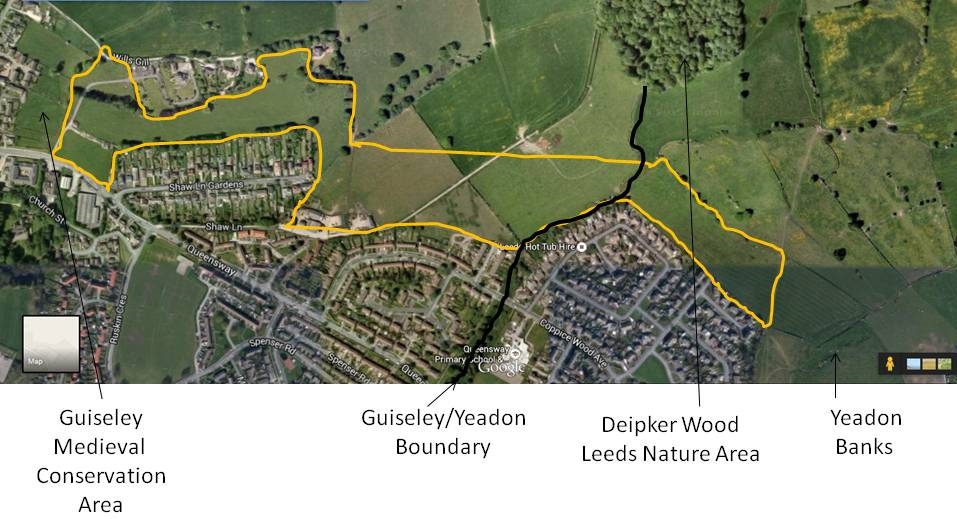
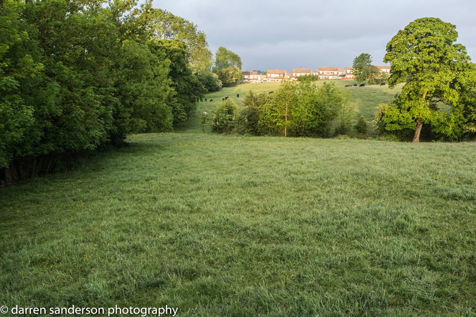
Urban extension from Wills Gill to Yeadon Banks. Does this merge settlements? Is this an encroachment of the countryside? You decide
In an earlier meeting on Monday13th July, that the Aireborough Neighbourhood Forum had with the Chief Planner, Tim Hill, and Cllr Richard Lewis, it was agreed that Tim Hill would meet with the Forum and Councillors, after the public consultation to look at views raised. The Forum has already commented on the Leeds sustainability reports, and in conjunction with a number of people around Aireborough will be working on these for the public consultation.
The ANDF has major concerns with the Leeds publication site allocation plan – key of which are
- Following research, the methodology for the green belt is not one we consider to be comprehensive, as required by the Leeds Inspector, or done in full accordance with the NPPF, for a number of reasons . We are having discussions with various professionals and Government Officers on this. The reviews done in places like Calderdale and Cannock Chase have taken a more objective and independent approach, in our view; and they seem to be the rule, rather than the exception.
-
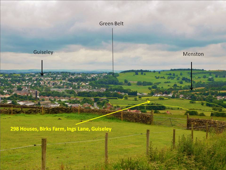
Is there nowhere better in Leeds to build 83 houses than on special landscape area at Coach Road, Guiseley
Based on evidence and Leeds own assessments we strongly disagree that the green belt sites chosen in Aireborough are those that do ‘least harm to green belt purpose’, or contain houses that cannot be accommodates elsewhere in the City on more sustainable non-green belt sites (para 4.1.4), as Leeds City Council have stated. All the sites below are green belt and still fulfil a number of green belt purposes:-

- The major urban extension at Ings Lane, Guiseley (3026), for just under 300 houses, is not infill – it joins the settlements of Guiseley and Menston. It should not matter that part of Menston lies within the Leeds City boundary, it is still Menston. The green belt in this area also separates the urban areas of Leeds/Bradford from rural Wharfedale, and is important to landscape character
- The major urban extension between Banksfield, Yeadon (1255b), and Wills Gill (3029), Guiseley for 370 houses is urban sprawl, that encroaches on the openness of the countryside, does not have stong, defensible boundaries, merges settlements, and has an effect on the historic characteristics of both Guiseley Conservation Area and Yeadon Banks. It also strongly affects landscape character. And that is before we get to infrastructure and other impacts.
- The site at Hawkstone Avenue/Hollins Hill (4020) for 80 houses, has serious implications for landscape
4020 Hollins Hill, Guiseley – What does this do for landscape character?
character, is a working farm, is designated special landscape area, and even in Leeds’ own review will encouage urban sprawl, and is already near a dangerous road junction. There must be better places in the City of Leeds to build 80 houses – especially now the Governement has given more incentives for brownfield development.

- The three sites at Coach Road (1180a, 1311a and 2163a) are designated special landscape area, are in or near a Guiseley Conservation Area, provide access to the countryside, and are on an estate that already has difficult access issues. Again, there must be a better location in Leeds for 83 houses.
- Site 1221 Gill Lane, Nether Yeadon, is the setting for the historic Low Hall, as well as the new Nether Yeadon Conservation area. In a recent representation to the Council against the conservation area, developers stated they would not be able to build houses in keeping, because it would not make the site viable – however Leeds have still put the site in for 155 houses, which is far too dense a number for the landscape character.
Aireborough Targets
Developers have said building houses in keeping with Nether Yeadon makes the site 1221 unviable – but it is still in the allocations.
Altogether Aireborough is targeted with 2,300 houses between 2012 and 2028.
Between 2012 and 2015 – 967 have either been built or have planning permission
This leaves a total of 1,333 to find room for
Of these, the site allocations propose that
1,215 are on green belt
32 on green field
30 on brownfield
Total 1277
the overall target is then reduced by the remaining 56 as Low Mills was a dropped site
That means that 95% of sites to be found are green belt, whilst of the original target 52% are green belt.

You must be logged in to post a comment.